[Extreme Photography] Aerial Photography of Uluru at 10,000 Meters (Uluru / Ayers Rock)Wu Chao Hui (JEFFI CHAO HUI WU) This is a photo of Uluru (Uluru / Ayers Rock) taken at a speed of 893.1 kilometers per hour and an altitude of 10,000 meters. The vast majority of people gaze up at it from the ground, while I captured it during a commercial flight, using my lens to achieve a precise interception from the southwest at a bearing of 235 degrees, all within a window of less than three seconds. There was no prior notice, no stopping, and no retakes. The photo clearly shows even the surface projection, with all the curved textures, cliff line projections, and angles of sunlight perfectly aligned with the time, direction, and flight path. You can easily find thousands of photos of the big red rock online, but it is extremely difficult to find an original image like this one that incorporates latitude and longitude, altitude, high-speed status, flight direction, and time of capture. It is not just a landscape photo; it is a verifiable, reconstructable archive of a civilized landform. Aerial photography captures visual sensations, while my work locates the structure of the Earth. Others rely on aesthetics, I rely on precision. Others depend on light, I depend on deduction. What I capture is not a photograph, but a data point with coordinates, a spatial fragment that can be archived. I am not pressing the shutter; I am seizing a node of civilization from high above. Before I photographed the Grand Red Rock, I had already conducted continuous shooting from multiple positions along the flight path. All images have clear time, location, speed, and angle. I am not recording beauty; I am intercepting reality. The shooting took place on August 2, 2025, during a flight from Bali to Sydney, with a departure time of 12:40 PM. The filming was completed in the later part of the flight, over the Australian inland. As the plane approached Uluru (Ayers Rock), the captain specifically announced over the intercom: "Passengers on the right side can see the world-famous Ayers Rock." Moments later, the captain deliberately adjusted the flight path to give passengers on the left side a chance to enjoy the view as well. This thoughtful maneuver is extremely rare, and it was at this moment that I captured the core images with remarkable precision. This was not a coincidence, but rather a result of recognition, judgment, and preparation leading to a decisive shot. The following are key photos that I personally took during this segment of the Dahuoyan航段. They are not only individually rare but also collectively form a continuous record of a geomorphological profile. Each image is fully labeled, with highly specific information that cannot be easily imitated, downloaded, or copied. Anyone attempting to replicate them can only mimic the surface colors and cannot restore the temporal and spatial context of the moment they were captured. 1. Uluru Aerial shot: Uluru, Northern Territory, Australia Latitude and Longitude: 25.1559°S, 131.2174°E Shooting time: August 2, 2025 15:46:58 Photographer: Wu Chaohui Photography By JEFFI WU Shooting direction: 235° Southwest Altitude: 9971.9 meters Flight speed: 893.1 kilometers/hour Straight-line distance: 29.53 kilometers Image Description: This photo was taken on August 2, 2025, at 15:45:25, with latitude and longitude coordinates of: 25.0568° S, 131.0133° E, corresponding to Uluru in the central Northern Territory of Australia — also known as Ayers Rock. 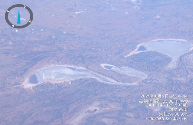
[图 1/7] This is an aerial photograph of Uluru taken by JEFFI WU from a flight at an altitude of approximately 9,966 meters, traveling at a speed of 930.2 kilometers per hour, heading 206° (south-southwest). In the image, the world-famous red monolith of Uluru is illuminated by the evening sunlight, showcasing striking red-orange layers and natural crevices, creating a powerful visual impact. 2. Kata Tjuta (also known as The Olgas) in the Northern Territory of Australia (see image below) The following image information Shooting time: August 2, 2025 15:43:47 Photographer: Wu Chaohui Photography By JEFFI WU Coordinates: 25.0202° S, 130.7676° E Direction: 214° (South-Southwest) Altitude: 9952.4 meters Speed: 941.4 kilometers per hour Image description: Captured during the flight, it records the spectacular scenery of Kata Tjuta (also known as The Olgas) in the Northern Territory of Australia. Kata Tjuta is located in Uluru-Kata Tjuta National Park and consists of 36 massive red dome-shaped rocks, with the highest reaching 546 meters. Like Uluru, it is a sacred site of the Anangu people, the Indigenous Australians, carrying a rich history of culture and legends. From nearly ten thousand meters above, the rock formations resemble a series of undulating red waves, exuding the vibrant colors of the Australian outback. 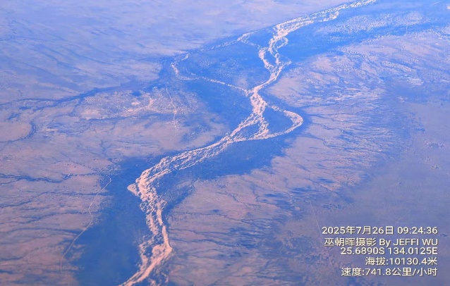
[图 2/7] 3. Australian Inland Desert (see image below) Shooting time: July 26, 2025 09:21:51 Photographer: Wu Zhaohui Photography By JEFFI WU Coordinates: 25.9433° S, 134.2015° E Altitude: 10109.8 meters Speed: 737.4 km/h Image Description: Captured during flight, located in a remote area in the southern part of the Northern Territory of Australia, typical of the Australian inland desert and semi-arid zone. From an altitude of approximately 10,110 meters, the natural gullies and dried riverbeds winding across the land can be clearly seen, resembling a dense network of tree roots or blood vessels, showcasing the magnificent textures left by natural erosion and water flow. The surface vegetation in this area is sparse, with exposed soil and rock layers displaying an intermingling effect of light brown and gray-blue under sunlight. The "river networks" in the photo are mostly dry, only briefly filled with water during seasonal rainstorms. 图片加载失败: D:\SW\jw_soft\Translate_Software_翻译工具\translator_single_单语版\temp\4923e8e6b5c7457d83bf72e4bcd59057.jpeg 4. Kimberley Coast (see below) Shooting time: August 2, 2025 14:28:37 Photographer: Wu Zhaohui Photography By JEFFI WU Coordinates: 18.0582° S, 122.3595° E Direction: 207° (South-Southwest) Altitude: 10079.7 meters Speed: 934.6 km/h Image description: Aerial photography at an altitude of 10,000 meters, located in the coastal area of the northwest region of Western Australia, near the Kimberley coastline north of Broome. The coastline can be clearly seen in the image, winding between the azure Indian Ocean and the light-colored sandbanks, with some areas of the sea displaying a gradient from light blue to deep blue due to variations in water depth. The white sandy belt along the coast forms a strong contrast with the dark-colored terrain inland, while the waterways of the estuary and wetlands outline complex natural patterns on the surface. 5. The remote desert area southeast of Alice Springs (see image below) Shooting time: July 26, 2025 09:24:36 Photographer: Wu Zhaohui Photography By JEFFI WU Coordinates: 25.6890° S, 134.0125° E Altitude: 10130.4 meters Speed: 741.8 kilometers per hour Image description: Aerial shot taken in the remote desert area southeast of Alice Springs in the Northern Territory of Australia. The light-colored area in the image is a prominent river valley or alluvial plain, which shows almost no visible water flow during the dry season, but the erosion marks on the surface are clearly visible. 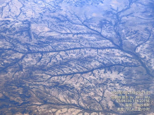
[图 4/7] The winding river resembles a light-colored ribbon, extending from the top to the bottom of the picture, surrounded by dense, tributary-like gully textures, showcasing the natural landscape formed by the long-term alternating effects of wind and water erosion. The inland landform is primarily in earthy yellow and light pink tones, creating a stark contrast with the bright colors of the river valley. 图片加载失败: D:\SW\jw_soft\Translate_Software_翻译工具\translator_single_单语版\temp\9aacca051238408c9b4afa8d33a0edb0.jpeg 6. Near the border between Western Australia and the Northern Territory (see below) Shooting time: August 2, 2025 15:32:44 Photographer: Wu Chaohui Photography By JEFFI WU Coordinates: 24.1114° S, 129.5934° E Direction: 243° (Southwest) Altitude: 9988.9 meters Speed: 953.5 kilometers/hour 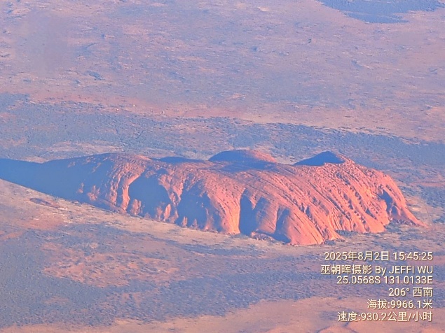
[图 6/7] 7. Western Desert of Australia Shooting time: August 2, 2025 15:02:20 Photographer: Wu Zhaohui Photography By JEFFI WU Coordinates: 21.2724°S, 126.0812°E Direction: 213° Southwest Altitude: 10,048.2 meters Speed: 943.8 kilometers/hour Image Description: This aerial photograph was taken by JEFFI WU over Western Australia, flying from the southern edge of the Kimberley region to the edge of the Great Sandy Desert. The photo showcases vast stretches of undulating sand dune belts, presenting typical aeolian dune ridge topography, with a blend of pale orange ground and blue-gray patches of vegetation, illustrating the dynamic balance between the desert terrain and surface biotic communities. 图片加载失败: D:\SW\jw_soft\Translate_Software_翻译工具\translator_single_单语版\temp\8c7e2ce2578f49b08763e43590679f8d.jpeg Near the lower center of the photo, there is a striking circular black spot landform, suspected to be the remnants of an ancient meteorite crater or a wind-eroded lake, enhancing the geological and geographical research value of the photo. The entire image presents a richly layered texture of the desert under the illumination of high-altitude light, combined with precise temporal and spatial information, making this photograph not only visually striking but also an irreplaceable testament to a moment. This set of photos forms an aerial cross-section that takes off from the northern wetlands of Broome, traverses the central desert, and reaches Uluru. This is not traditional travel photography; it lacks beautification, post-processing, and is not meant to showcase beautiful nature. It is precise operation in flight, the result of systematic judgment, and a high-dimensional capture with only three seconds of decision-making space. The reason this set of images is rare lies not only in its bird's-eye perspective and clarity but also in the aerial photography database structure formed by all the supporting photos behind it. This is not a point-based display, but a complete data chain. I used a systems thinking approach, an engineering perspective, and a time-segmented positioning method to complete this series of shots. The direction of light, terrain shadows, flight speed, and flight path direction in each photo are all verifiable. This means they are not just visually appealing images, but can serve as research samples for comparing satellite layers, topographic maps, and historical landscape changes. I did not use a professional aerial camera, nor satellites, nor post-processing. I simply relied on years of accumulated judgment regarding flight paths, timing, angles, terrain, and light and shadow to achieve infinite precision within a limited space. Ordinary photographers often find themselves at a loss when faced with reflections on windows, cloud interference, and airplane vibrations, while I have learned to filter out information noise amidst all distractions, coordinating my body, perspective, experience, and equipment to transform moments into structure. Not just anyone sitting by the window can capture such images. It is not enough to have the intention; one must have insight, calculation, and the ability to intercept. True aerial photography is not about how high you fly, but about whether you can capture anchor-level images amidst speed, direction, structure, and data. These images are destined to be uncopyable and cannot be simply replicated. Each picture is a collision of spatiotemporal coordinates, and each pixel is a fragment of the structure of civilization. This is my aerial photography series of ten thousand meters. It is not for aesthetics, but to let civilization find its origin on a real image for the future. |